July, August, and September are the golden months for hiking in the Northwest. This year four of us, all retired or semi-retired, discovered our mutual interest and proceeded to share some epic hikes, all on weekdays when the crowds were almost non-existent. A pianist, two cellists and a bassist walk into the woods sounds like the beginning of a joke but we make a compatible group. Conversation is pretty much non-stop since we all share at least two interests! For example, there have been some very learned discussions of the properties of cello vs bass rosin which would no doubt have been riveting for almost anyone overhearing us.
This is a long post with lots of pictures. Be patient.
Eagle Peak Saddle
In late June, Jim and I took our first Mount Rainier trip of the season.
Eagle Peak Saddle is near the southern boundary of the National Park, with the trailhead near the Longmire Lodge. The elevation gain is nearly 3000 feet over about 3.5 miles but the trail is well-maintained and doesn't seem all that steep.
 |
| Rainier from the trailhead |
We walked through forest and open areas as the trail went up. Switchback after switchback. And up some more.
 |
| Mt Adams on the left, St Helens on the right, and Hood looking very small in the far distance |
 |
| Mount St Helens using my trusty zoom lens |
 |
| Mount Adams |
 |
| Mount Hood under extreme magnification about 90 miles away |
 |
| Some interesting foliage at the Saddle |
 |
| Oddly, I didn't notice this on the way up |
On the way down, we met a ranger and a young woman in training to be a ranger. We chatted amiably for a few minutes and then the ranger asked us if we had seen anyone up the trail who needed help. We said no. Then he got very stern and said he was also a U.S. Marshall and if we were lying to him we could be charged with a crime. We still hadn't seen anything and told him so. What a jerk.
Tolmie Peak
The next hike was my first one with Bennett, who is recently retired, a cellist and fellow orchestra member of
Philharmonia Northwest.
Tolmie Peak is one of my favorite hikes and I have done it several times. To get there, you have to drive on a gravel road for about 15 miles through forest and some ugly clear cuts. It also seems to take forever and gets your car really dusty. This is on the west side of the park (Mount Rainier NP, that is) south of the Carbon River entrance so generally it is uncrowded.
There are many reasons I love this hike. When I was feeling depressed about my job prospects in 2010, since Boston Scientific had fired their entire Redmond work force, hiking Tolmie Peak really changed my outlook - the first time I fully experienced wilderness therapy. I hiked it with Anna once and saw some tiger lilies along the trail which is always a cool thing. The trailhead is rather squalid, but as soon as you leave the parking lot, you are walking on the shores of beautiful Mowich Lake and eventually, just before the final push to the summit, you get to admire the utterly pristine Eunice Lake. At the top of the peak, there is a lookout tower used for spotting fires back in ancient times when airplanes were uncommon and satellites were nonexistent. It's nice to climb around on and it's comfy (relatively speaking) to sit on the deck with your feet dangling as you eat your lunch and take in the view. And needless to say, the views of the Mountain are spectacular!
Tolmie Peak is named after
William Fraser Tolmie, a Hudson's Bay Company employee serving at Fort Nisqually in the 1840s and 1850s. He seems to have been a humane man who, unlike the American settlers, respected the local tribes and treated Indians as business partners (which they were) rather than savages who had to be exterminated. He went so far as to support and advocate for
Chief Leschi who was hanged unlawfully by the Americans for murder after the Puget Sound War of 1855-56. Tolmie made the first recorded exploration of the Mount Rainier area by a European and, during the expedition, he climbed one of the peaks in the area, possibly Tolmie Peak, along with two Indian guides who traveled with him.
 |
| Mowich Lake |
So... we set off on the trail along Mowich Lake and continued through forest, the trail rising and falling over the three to four miles to the lookout. This hike always seems longer than I remember it being. The day was cloudy but we had hopes the clouds would burn off allowing us to see the sights.
 |
| The forest was deep and it was dark |
 |
| Lake Eunice - there is our destination on the horizon! |
As we passed Lake Eunice there were fields of thousands of Avalanche-Lilies and the sky showed signs of clearing. We were also lucky enough to spy a Tiger Lily in full bloom. We headed up the final slope to the summit and had lunch at the lookout.
 |
| An abundance of Avalanche-Lilies |
 |
| Tiger Lily sighting! |
 |
| Tolmie Peak Lookout |
 |
| Eunice Lake from the lookout |
We spent quite a long time at the summit waiting for the clouds to go away. They didn't. What we hoped to see was this:
 |
| The mountain on a better day |
What we actually saw was this:
 |
| Where Mount Rainier should be |
We had a good time nevertheless.
I learned something new on this hike: there is a privy at the top of Tolmie Peak! It is on the edge of a cliff and behind some bushes for privacy on one side but, on the north side, it is open to the Cascades all the way to the horizon. As it turned out, I was quite in need so, long story short, I used this little jewel for its intended purpose. Considering the awe-inspiring view to be enjoyed while relieving oneself here, this must be one of Washington's best places to urinate.
 |
| Room with a view |
After this inspirational experience, we headed back down the mountain and got another view of Lake Eunice. Notice the columnar basalt cliffs across the lake. This kind of formation is more typical of Eastern Washington but here it is in the central Cascades.
 |
| Lake Eunice again |
After the hike, we stopped for dinner at the Buttered Biscuit Too restaurant on Highway 410 in Bonney Lake for massive servings of high calorie, high cholesterol American food. Just what the doctor ordered!
Summerland
A few weeks later, in late July, Jim, Juha, and I decided to hike to Summerland, one of the most beautiful alpine meadows in Mount Rainier National Park. They had never done this hike before but I had been there a few years earlier with the Mountaineers. Unfortunately, that was on the first day of a heat wave with temperatures in the 80s. Apparently, I didn't drink enough water and ended up feeling quite sick on the way down.
I wanted to erase that bad memory by hiking in better weather with plenty of water (enhanced with electrolytes) and good company.
The trail begins in lush old growth forest and ascends about 2000 feet over about 4.5 miles making it a relatively easy hike.
 |
| Lushness along the trail |
Along the way, Frying Pan Creek was always heard and sometimes seen, in this case about 50 feet below us.
 |
| Frying Pan Creek |
Once in awhile we get a peek through the trees at the larger world.
 |
| Waterfalls in the distance |
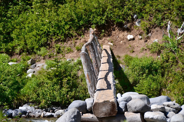 |
| Somewhat precarious looking bridge over the creek. The handrail is a nice touch though. |
After crossing the creek, the trail gets steeper with several switchbacks.
 |
| Approaching Summerland we get a hint of views to come |
And then we arrive!
 |
| Summerland! |
We ate our lunches under the watchful eyes of the hungry locals. I stood up for a minute, looked back at my lunch, and saw a chipmunk energetically trying to open one of my plastic food containers! Although unsuccessful, you have to admire their dedication.
 |
| Our lunchtime guest |
 |
| Lots of Marmots here |
After eating and resting a while, we explored the meadows and decided to continue up the trail to see some snow.
 |
| Summerland meadows |
 |
| It's hard to get enough of this scenery. Here Jim and Juha ponder hiking up and out of the meadows. |
 |
| Plenty of wildflowers in bloom |
It is interesting how a very small change in elevation results in a totally different landscape. Green meadows give way to rocks, ice, snow, and lichens. Jim and Juha wanted to take a walk on the snow fields but I decided to sit on a rock and contemplate my surroundings.
 |
| Suddenly it's winter |
 |
| Jim and Juha snow walking while I sit and admire the view. |
 |
| Pretty sure we can see the Stuart Range in the distance to the northeast |
 |
| Looking back towards Summerland |
 |
| Back to the meadows |
 |
| Group selfie before we headed back down |
I remember being very reluctant to leave this beautiful place. But you know what they say about all good things.
Funny story: just before we arrived at the meadows, I took a big step up as the trail went over some large rocks. I heard a ripping noise but assumed it was just some velcro on one of my pockets. After a few minutes I looked down and realized the front of my pants had ripped from one of my knees almost up to the belt line. What to do? Lady hikers are on the trail too! Oh no! The ten essentials don't include extra pants (at least in my case) or sewing supplies either. While I appreciated the extra ventilation, my situation seemed socially unacceptable even in the wilderness. Luckily, Juha came to my rescue and loaned me an extra pair of shorts that he had thoughtfully included in his backpack. I put them over my pants to create the sartorial ensemble you see below.
 |
| The well-dressed hiker |
On the way home we stopped at Wapiti Woolies in Greenwater for the traditional (at least for me and other sensible people) huckleberry milkshakes. Just what you need after a long hike in the mountains!
Midsummer Musical Retreat
I drove to Walla Walla at the beginning of August for a week of wine, non-stop music making, wine, concerts, socializing, and more wine. That is the gist, the vibe if you will, of the
Midsummer Musical Retreat, a music camp for adult amateur musicians that is held every August on the campus of Whitman College. This year we had over 200 instrumentalists and singers and over 30 faculty members. People come from all over the Northwest and beyond with the majority, of course, from western Washington. One violinist came all the way from Scotland!
This year, I was in two prearranged groups: a piano quintet and a bass quartet.
Our quintet, shown below, played the 2nd Movement of Ralph Vaughan-Williams' Piano Quintet in C minor. Our coach, kneeling in front, was
Charles Enlow who provided us with much valuable input on the subtleties of this piece which are numerous. My hiking friend, Jim, is second from left and is the pianist. The cellist, Rumei, is principal cello in my home orchestra,
Philharmonia Northwest. Violinist Dave and violist Mark are from Canada.
 |
| Our Vaughan-Williams quintet + coach |
I don't have a picture of my other group, a bass quartet, but we played the third movement of
Colin Brumby's Suite for Four Double Basses coached by
David Brown. David is an incredible bass player, wonderful teacher, and a great guy. We had a good time.
After rehearsing with our various large ensembles (Festival Orchestra for me), chamber music and jazz groups Tuesday through Friday, Saturday was concert day at Whitman's Cordiner Hall.
 |
| Jazz group at Monday evening's faculty concert. David Brown on bass. |
 |
| Cello Ensemble at Friday night's Dinner Party |
 |
View from the bass section as conductor Roupen Shakarian prepares to take the podium for Saturday's Festival Orchestra dress rehearsal
|
 |
| Saturday afternoon rehearsal with the chorus accompanied by the faculty orchestra (with selected non-faculty players too, e.g. me) |
So that was my summer music event. And now, back to the mountains.
Grand Park
All four of my retired guys mid-week hiking group got together for this one. Grand Park is a huge alpine meadow near the northeast corner of Mount Rainier National Park. I have seen it several times from above from the Mount Fremont Lookout which is an easy hike from Sunrise. I have always wanted to visit and this was my chance.
There are two ways to get to Grand Park. You can approach it from Sunrise with a long descent of nearly 2000 feet through Berkeley Park. This is a long hike and you have go back up to Sunrise at the end. A better approach, at least in my opinion, is via Lake Eleanor which is only 8 miles round trip with 1100 feet of elevation gain. This is the route we took in mid-August.
The trailhead is accessible via forest service roads and we were successful in finding it thanks to our GPS system.
 |
| Preparations at the trailhead |
We followed a primitive trail for about half a mile along Eleanor Creek and reached beautiful Lake Eleanor. As you can see, the weather was beautiful and calm, turning the lake into a looking glass.
 |
| Lake Eleanor |
After another half mile or so, we entered Grand Park. Unfortunately, we were a bit late in the season for wild flowers, but the views were impressive nevertheless.
 |
| The east end of Grand Park |
 |
| The Mountain from the heart of Grand Park, our lunch spot |
 |
| A zoom lens gives a sense of the scale of this landscape |
 |
| Mount Fremont on the right with its lookout from which I viewed Grand Park several times |
 |
| The western edge of Grand Park |
We walked across most of the width of this giant meadow and returned the same way.
 |
| The Mountain was venting steam |
 |
| Goodbye Grand Park |
We got back to the car in good shape and, duh, made a huckleberry milkshake stop at Wapiti Woolies on the way home.
Summerland 2.0
Anna and Pierce had never been to Summerland and, even though I had been there about a month earlier, I saw no reason not to go again because... it's Summerland! That turned out to be a good decision and this hike turned out to be one of the summer's best. And that was not only because I got to hike with my daughter and son-in-law (wonderful as that always is), but also because we made it to an incredible and hard to reach location I wondered if I would ever visit.
 |
| A and P heading up the trail |
 |
| Summerland |
 |
| Shelter and picnic area |
 |
| Pierce and Anna |
 |
| Babbling brook in the meadows |
The meadows at Summerland are beautiful and the trip is well worth it simply to soak in the wildflowers and the grandeur of the setting. However, 1.5 miles beyond the meadows and 900 feet higher, Panhandle Gap beckons, making for a 12 mile hike with nearly 3000 feet of total elevation gain. A lot of snow had melted since mid July so, not getting any younger, I decided to go for it. No big decision for the young ones; of course they were up for it.
We walked up and out of the meadows into the rocks and minimal vegetation of the high mountains. We crossed a stream on a log bridge and, with some difficulty, followed the trail which in some places was marked with stone cairns and in others with other bootprints in the snow. We crossed three snowfields, two of which were reasonably flat and felt safe. Just before we reached the Gap, however, we had to scramble over some large boulders, cross about 15 feet of snow that sloped sharply down on one side, and then scramble over some more boulders to get back on the trail. Slipping down the snow slope would not have been fatal but it would definitely not have been pleasant either. Fortunately, we all crossed it both coming and going without mishap.
 |
| Pierce showing off his balancing skills |
 |
| Documenting the trail to Panhandle Gap |
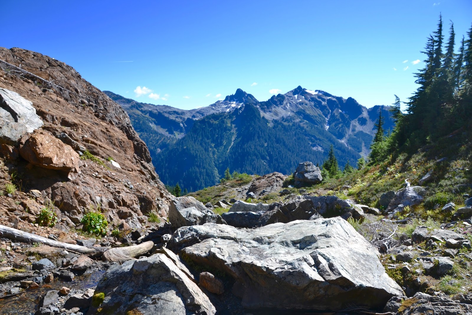
We made it to the gap and were rewarded with stunning views in all directions. Not many people make it to this place and we had it mostly to ourselves even though we were hiking on a weekend. Pictures cannot do it justice and I can say with all sincerity that this was one of my most memorable nature experiences.
 |
| Looking southwest from Panhandle Gap |
 |
| The Mountain from Panhandle Gap |
 |
| Mount Adams through the haze |
Reluctantly, we left this indescribable place and retraced our steps back to the meadows and on down the trail.
 |
| Fresh snowmelt on the way down |
 |
| A last look at the meadows as we head back down |
The last couple of trail miles were rather excruciating since all three of us were extremely tired and we had almost run out of water. Luckily, I didn't have to drive home and rested my eyes rather thoroughly in the car until we reached Greenwater for the customary milkshakes. Rarely have they tasted so good.
Bean Creek Basin
On Labor Day weekend, Anna and I decided to get out for a hike to
Bean Creek Basin in the Teanaway country north of Cle Elum. It was too late in the year to see many wildflowers but it felt good to get out in the mountains. As we ate our lunches in the middle of the basin, there were loud crashes of thunder echoing off the surrounding cliffs although we couldn't see the lightning. Then for the only time during this hiking season, it started to rain. We broke out the rain jackets and high-tailed it back to the car by which time the sun was out again.
Naturally, post-hike milkshakes at Cle Elum's McKean's Drive In were had.
 |
| Not sure what these are but we didn't eat them |
 |
| On the trail |
 |
| Entering Bean Creek Basin |
Yellow Aster Butte
My last major hike of the season was to
Yellow Aster Butte with Juha. The trailhead is just off the Mount Baker highway 2.5 - 3 hours from home but well worth the drive. There are two parts of the trail that are very steep: very close to the trailhead and the final slope to the top of the butte where the trail is so steep it is tempting to be on your hands and knees. Also, the WTA description of the junction where one fork goes to the butte is confusing since as you go along there are several trails branching off and we nearly took more than one of them. And the distance to the junction seemed much further than claimed in the description. Juha's GPS was invaluable.
Despite these inconveniences, we persevered through the ridiculously beautiful mountains and found ourselves on the summit with fantastic views and some nice Canadians (redundant I know) to talk to. They pointed out some mountains to us on the northern horizon which are in Canada and they generally made themselves pleasant.
On the drive home, we hunted for milkshakes in some of the small towns near the trailhead without success. We were forced to settle for ice cream. An unpleasant compromise but we survived.
 |
| Mt Baker from the trailhead |
 |
| Some autumn colors already appearing |
 |
| It would have been nice if the WTA description had mentioned that there is a SIGN where you need to turn! |
 |
| Along the trail |
 |
| Some of last year's snow still hanging around |
 |
| Mt Baker from the top of the butte |
 |
| Canada in the distance |
 |
| Looking east at the North Cascades |
 |
| The bigger picture looking east |
 |
| Looking back at the high point of the butte |
 |
| Mt Shuksan |
Later in the fall, Anna and I hiked the Little Si trail for some wilderness therapy (it works) where I tragically left one of my hiking sticks in the outhouse at the trailhead. We had fun (we always do) but Little Si is a bit pedestrian (yeah, that's a pun) compared to Rainier or the North Cascades.
And so ends my epic summer in the mountains.


Wow, you had an amazing summer. Really beautiful photos!
ReplyDelete