Day 1
On Thursday a few weeks ago (September 24, 2015) I picked up Mom at about 6:45AM and we steered for the Tetons. The weather was clear and, although it was rush hour, after we got on I90 traffic was light and got even lighter as we got past Issaquah. Tetonia is over 800 miles from Seattle and my plan was to keep driving with the possibility of finishing the drive in one day. We stopped at a couple of rest areas before we got to Spokane and then had lunch at a DQ in Coeur D'Alene, Idaho. After Spokane, we were in unexplored country as far as I was concerned.
As we proceeded into the mountains of northern Idaho, the air grew smoky although we saw no fires. We stopped for gas in Wallace of
Big Burn fame (by Timothy Egan) and drove through the quaint downtown. Continuing east on I90, the country opened up and became relatively dry but with lots of trees on the hills. We passed through Missoula Montana, and turned south on I15 just before I90 enters Butte. By this time we had been on the road for about 8 hours and I was starting to feel it. We made it as far as Dillon MT and stopped for dinner around 5:00PM. Although tired, I decided to push on to Tetonia to give us 3 full days there, allowing us to spend a day at Yellowstone.
The last 2 1/2 hours on the road were not fun. I15 seemed to take forever to reach the Idaho border and the bugs on the windshield were getting so thick it was hard to see in the gathering darkness. At last we found the turnoff onto Idaho 33 and started the final hour or so of the trip on a two-lane road in total darkness. I was reaching the end of my driving rope. At one point, the lights of what appeared to be a vast city appeared, mystifying me entirely since we were in the middle of nowhere. It later turned out to be the town of Rexburg with a population of a mere 25,000. It sure looks big in the dark though.
Finally, after at least 12 hours of driving, we saw the sign for Tetonia. Following directions supplied by Valerie, we turned right after the gas station. However, the name of the road was not one of the three possible names it should have been so I went back to the highway thinking there might be another gas station in town. However, in about 30 seconds we were completely out of town. Feeling muddled and stupid after so many hours of driving, I called Valerie for help and, with an assist from Bob (running down the driveway with a flashlight), she guided us in for a safe landing at the renowned cabin of Valerie and Bob.
The cabin is nicely decorated with lots of family pictures and artifacts as well as western themed items. I crawled off to sleep in the neighboring art studio and soon passed out.
Day 2
When I awakened the sun was about to rise. I peeked out the window and saw this:
 |
| Sunrise in Tetonia |
Arriving in the dark, I didn't quite know what to expect in the way of scenery from the cabin but, with daylight, the eastern horizon exceeds all expectations.
After a delicious breakfast of pancakes and eggs, Valerie, Mom, and I took a walk around the property.
 |
| Mom and me at breakfast |
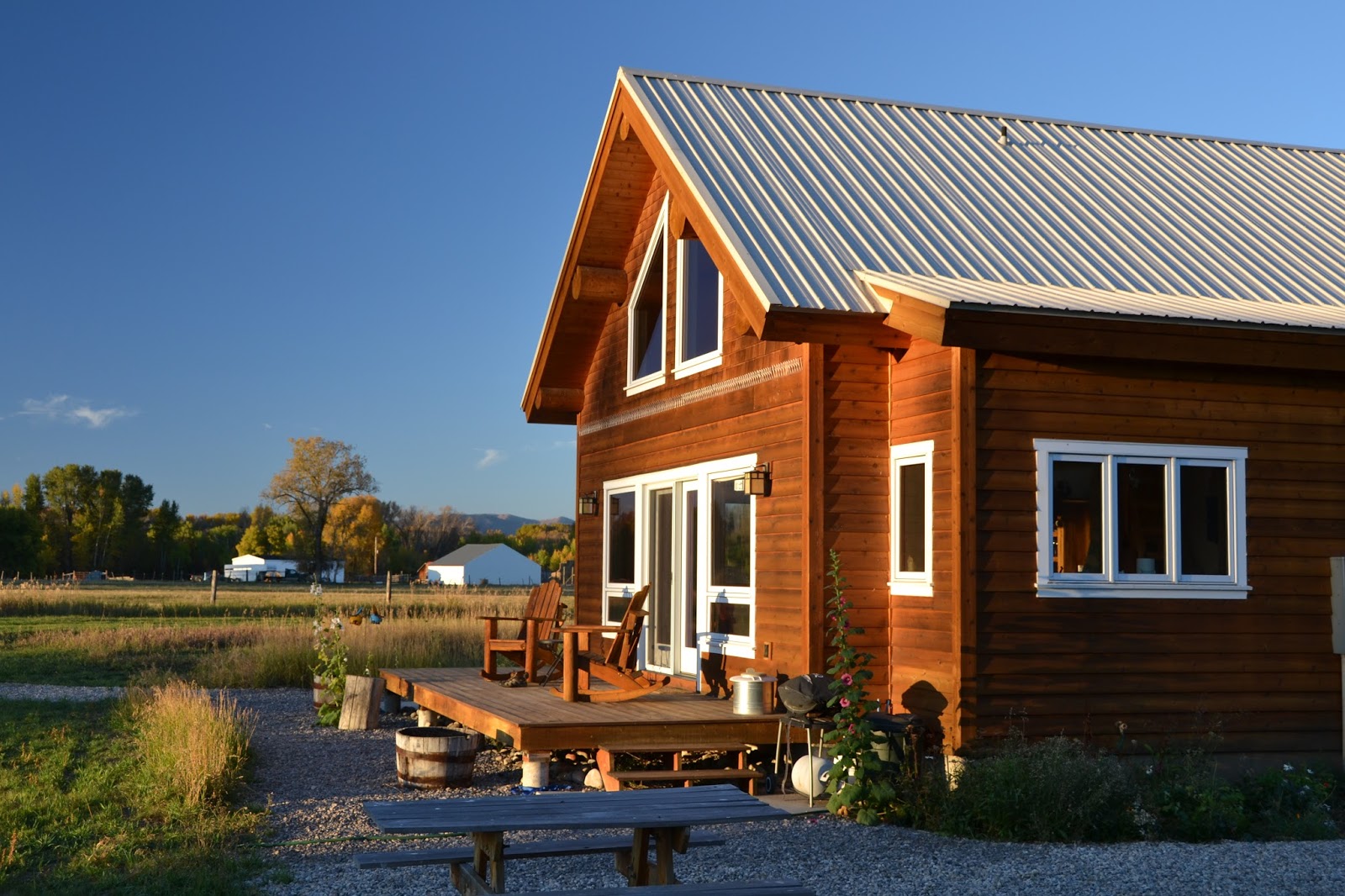
 |
| The Cabin |
 |
| Cabin and Art Studio (I stayed in the bedroom on the far right of the art studio) |
 |
| It must be nice to have your own Aspen grove |
Later in the morning we drove to the local metropolis of Driggs ID (population 1660) where we visited the airport with its Warbirds Collection and restaurant. It seems that Bob has sighted Harrison Ford in the restaurant a few times. Apparently, he spends quite a bit of time in the area and flies in using his own plane.
 |
| North American something-or-other of late WW2 vintage |
 |
| An early MIG |
 |
| Harrison Ford sat here! |
We went on south to the town of Victor (population 1928) and, if I remember the sequence of events correctly, bought a huckleberry pie ($20 but it was worth it) at the farmers market and had lunch at Grumpy's Goat Shack. This hamburger joint lives up to its name, the proprietor being positively surly. He got visibly impatient while my Mom and I were deciding what to order and was clearly a nasty piece of work. When you are mean to my mother, dude, you don't get a tip. Ever.
We headed back north to Driggs, where we stopped at
Guchiebirds Gift Shop owned by V & B's friends Guch and Chuck. The shop was nice but, for me, Chuck's workshop in the back was more interesting. Chuck is a luthier who specializes in building and repairing guitars as well as repairing other string instruments. We saw some of his works in progress and he does beautiful things with mother-of-pearl, usually wildlife themed.
Afterwards, we went back to the cabin for dinner and huckleberry pie with ice cream. As the sun set, we sat on the porch and watched the colors change on the Tetons as the nearly full Moon rose behind them.
 |
| How's this for purple mountain majesty? |
Incidentally, the origin of the term "teton" is disputed, but the most common explanation is that "Grand Teton" means "large teat" in French. I'm gonna go with that.
Day 3
We got up early for a full day at Yellowstone National Park which is an hour or two away from the cabin. The national park, as you may know, sits on top of a super volcano. The map below shows the rim of the volcano's caldera and gives you an idea of the scope of this restless monster lurking just below ground.
17 million years ago, the hotspot that is now the Yellowstone super volcano was in eastern Oregon and was the source of the multiple lava flows now covering eastern Washington and eastern Oregon to a depth of up to a mile. The Snake River plain in southern Idaho is the result of the hotspot's movement (or, more properly, the North American plate's movement over the hotspot) ever since. I once read that the hotspot may be the result of a large meteor impact but I don't think this hypothesis has been proven.
So, if you visit Yellowstone, know that you are on top of a volcanic monster and no one really knows when it may decide to erupt again. The last eruption was 640,000 years ago but the next one is unpredictable. Scientists say that a major eruption event would result in huge ash falls across the great plains producing mass starvation across North America. We would require major food aid from other countries for years afterwards to survive and, given our foreign policy over the past 30 years or so, who knows if the world would care?
We drove into the park at the west entrance and stopped at a pretty waterfall on the Gibbon River.
 |
| Gibbon Falls |
We continued on toward Norris, stopping at the Norris Geyser Basin where we got out of the car, walked around and looked at the steam and hot springs all around. Such a bizarre landscape.
Also, I bought a National Park Passport at the Museum and Information Station. At any National Park, monument, or museum you can stamp your passport to show that you were there. I ended up getting several stamps at Yellowstone.
 |
| Steam venting in Noris Geyser Basin |
 |
| More steam venting in Noris Geyser Basin |
After a short time, we headed for the Grand Canyon of the Yellowstone stopping at a viewpoint called Artist Point.
 |
| Grand Canyon of the Yellowstone. Lower Falls from Artist Point. |
 |
| Grand Canyon of the Yellowstone |
We admired the views for quite some time before moving on to a picnic ground upstream where the Yellowstone River is quite placid. You would never know that only a small distance downstream there is a huge waterfall.
 |
| The Yellowstone River where we had our picnic lunch |
After a delicious lunch packed by Valerie, we went south toward Yellowstone Lake (elevation 7733 ft or 2357 meters) which is 410 feet deep or 131 meters. Along the way we saw a herd of Buffalo resting in the mud of a creek bed. Apparently, all that grazing is extremely exhausting. But what goes in must come out.
 |
| Buffalo at their ease in the mud |
 |
| A genuine buffalo chip |
After gawking at the sleepy yet muddy herd, we continued to a bay of Yellowstone Lake called West Thumb and stopped at the West Thumb Geyser Basin. While Bob napped in the car (he had been doing all the driving), Valerie, Mom, and I walked into the basin. They sat on a bench while I circumnavigated the place on a wooden trail.
 |
| West Thumb Geyser Basin |
 |
| West Thumb Geyser Basin - many holes full of hot water |
 |
| West Thumb Geyser Basin - nice shade of turquoise here |
 |
| West Thumb Geyser Basin - the most unsavory hot spring I saw |
When I had completed my circuit, I found Mom and Valerie chatting up a Chinese couple from Shanghai. The man could speak a bit of English but I don't think his wife could. She didn't try to talk much in any case. He taught me how to say hello in Mandarin, but I'm afraid I did not retain this knowledge.
Next stop Old Faithful! At which I got a stamp!
 |
| Old Faithful getting ready to do its thing |
 |
| Getting going |
 |
| Old Faithful in full spew! |
I've gotta say, Old Faithful is pretty cool. We arrived about five minutes before the next predicted eruption and the geyser faithfully performed on schedule. Towards the end of the performance, the crowd applauded and some guy yelled "America!" - I'm still trying to parse the meaning of both of those responses. Applause for a good performance by a non-conscious entity? "America!" meaning geysers are only in the U.S.? Not true. Or that Old Faithful is somehow the result of American virtue? Ridiculous. I'm still working on it.
Afterward, I got another stamp! Then we went to the local restaurant and had drinks. I had a huckleberry margarita.
We made a big loop within the park and were now on the home stretch. Along the way, we found some more resting buffalo and, later on, some much more active elk.
 |
| Buffalo mostly quiescent |
 |
| Elk on the alert |
We ended the day with dinner outside the park in a little town called Island Park (I think) and a longish drive back to the cabin where I slept soundly.
Day 4
I awoke to another sunrise over the Tetons, this time with a gloomier, more brooding aspect. Apparently we were going to have some weather today.
 |
| Teton Sunrise |
We headed south from Tetonia and then east over Teton Pass (8431 ft, 2570 meters) to the small hamlet of Wilson where we saw a lady moose wading in Fish Creek. We turned north on the appropriately named Moose-Wilson Road, passing what I assume is a famous ski resort, the Jackson Hole Mountain Resort. We entered the Grand Teton National Park at the Granite Canyon entrance and proceeded on an unpaved road to the Laurance S. Rockefeller Preserve. Sadly, the preserve was closed for the winter although the date was only September 27. I guess winter can start early at these altitudes.
In a few minutes we arrived the Craig Thomas Discovery and Visitor Center (got a stamp) which had many interesting features including a large relief map of the park (a Ranger lecture was in progress) and several large lines in the floor pointing to the various peaks in the Teton Range.
Afterwards, we continued north stopping at many turnouts for pictures until we arrived at Jenny Lake where we found another visitor center closed for the winter.
Bob - please correct me if I am wrong about any of this or to add names of mountain peaks.
 |
| At a turnout along the road |
 |
| Another view from a turnout |
 |
| I believe this is Cascade Canyon near Jenny Lake |
 |
| Jenny Lake |
We continued north to the Jackson Lake Lodge for lunch. I stepped outside a few times to take some pictures.
We drove onward to the town of Jackson, home of Dick Cheney and other rich, conservative undesirables. The Elk Antler Arch was the most interesting sight in town.
 |
| No elk were harmed in the construction of this arch. They shed their antlers annually. |
Then it was back to Tetonia and the lunar eclipse. Unfortunately, there were clouds at moonrise but eventually they cleared allowing a good view of the blood moon. However, I failed miserably in my photographic efforts and have no pictures to show.
Day 5
I started for home early in the morning and made it as far as
Wallace, Idaho. Along the way, I took a scenic detour west of Butte on Montana Highway 1, the Pintler Veterans Memorial Scenic Highway, passing by the intensely blue Georgetown Lake and having lunch in the quaint little town of
Philipsburg, Montana. Then I put the pedal to the metal hoping I could make it to Wallace in time to take in the Oasis Bordello Museum and the Northern Pacific Depot Railroad Museum. Sadly, they closed half an hour after I got into town.
Along the way though, I stopped at one of the best rest areas I have ever seen. You can walk through a gate to the edge of the Clark Fork River.
The Clark Fork starts near Butte Montana and runs 310 miles, emptying into Lake Pend Oreille in northern Idaho. Its mouth is the site of the ice age ice dam which broke several times unleashing the enormous floods that sculpted eastern Washington about 12000 years ago.
I got into Wallace at about 4:30PM and checked into the 100-year-old
Ryan Hotel. Then I took a walk around town (a very short walk - it's a small town), had dinner and went to bed. I'm pretty sure I was the only guest that night since it was VERY quiet.
 |
| The Ryan Hotel with my Sube in front. |
 |
| I did not get a chance to visit this fine establishment |
 |
| This museum was also closed |
 |
| A quiet evening in Wallace |
Day 6
I got up bright and early and headed home. There was a little traffic going through Spokane but otherwise, I had the interstate mostly to myself. I crossed the River at Vantage and coming over Ryegrass Pass (elevation 2535 feet or 773 meters) heading west I was welcomed home by the sight of Mt Rainier on the horizon. Of course, I stopped in Cle Elum for a traditional American lunch at Mckeans Drive-In. where the best burgers and shakes in the world are made.
As I passed through Issaquah and southern Bellevue, I congratulated myself on my quick trip. However, when I turned north on I405 I was caught in the slow moving parking lot that is the new normal since the toll lanes were added. It was a great trip but it was good to get home.


Great write up! I'll provide the link to all of our future visitors.
ReplyDeleteDo you remember where the notable rest area is? I assume it's on the scenic side route, not I-90?
ReplyDeleteIt is on I90. Quartz Flats Rest Area (westbound) at reference post 58.22.
DeleteYou are correct that you picture is of Cascade Canyon. The peaks on the left (south) of the canyon are referred to from that view as the Cathedral Peaks. The highest point is the Grand Teton with Mt Owen (the snowiest) to the right and Teewinot to the left.
ReplyDeleteThe picture of the view from Jackson lodge shows Bivouac Peak in the center and Mt Moran (with the Skillet Glacier) to the left. Four pictures down from that is a great shot of Mt Moran towering over a grove of beautifully colored aspens.
As for Harrison Ford, he lives over near Jackson and I don't know how he commutes but my understanding is that he keeps a helicopter at the Driggs Airport that he flies as often as possible.
Nice photos. Looks like a fun trip. Thanks for sharing.
ReplyDelete